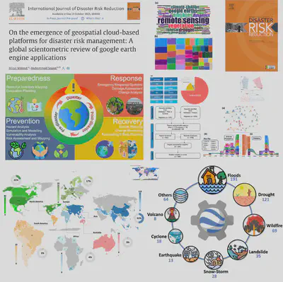
On the emergence of geospatial cloud-based platforms for disaster risk management: A global scientometric review of google earth engine application
Abstract
With the global upsurge in climatic extremes, disasters are causing more significant damages. While disaster risk management (DRM) is a serious global challenge, governments, stakeholders, and practitioners among many other actors seek advanced solutions to reduce disaster-related costs. Recently, Google Earth Engine (GEE), a cloud platform used for planetary-scale geospatial analysis using big-data, has gained popularity due to its applications in various fields. While the availability of free satellite data has facilitated long-term spatial-temporal trends and patterns identification, cloud computing emerged as a reputable tool in geo-big data analyses. Yet nearly after ∼15 years of its launch, the impact of such cloud-computing platform on DRM (risk assessment, monitoring, and planning) has not been carefully explored. Hence, a systematic review regarding the current state and trends in GEE applications to DRM is needed, which could provide the community with the bigger picture of the subject matter. Therefore, this study aims to investigate the advancement in DRM with GEE being the primary platform used. For this, 547 peer-reviewed studies published in 208 different journals during 2010–2022 were assessed. The current spectrum of GEE applications is dominated by floods, drought, and wildfires. For data type, most of the studies used optical data (Landsat and Sentinel-2). In terms of geographical distribution, China, USA, and India dominate with highest articles published. Within this research domain, three emerging research themes (floods, forest fire, and classification) are observed. Our results signify the emergence of GEE applications in DRM, which will continue making substantive progress on DRM-related multi-scale challenges.
Mirza Waleed
PhD Researcher | Google Developer Expert
I am a Ph.D. Fellow at Hong Kong Baptist University, specializing in geospatial data analytics techniques, cloud computing, and artificial intelligence for disaster risk management, especially for flood hazards. I am also a Google Developer Expert in Earth Engine category. My goal is to use geospatial technologies to create sustainable and resilient communities. Let’s connect and collaborate to make a positive impact.