Satellite-based evaluation of temporal change in cultivated land in Southern Punjab (Multan region) through dynamics of vegetation and land surface temperature
Abstract
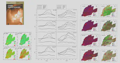
The rapid increase in urbanization has an important effect on cropping pattern and land use/land cover (LULC) through replacing areas of vegetation with commercial and residential coverage, thereby increasing the land surface temperature (LST). The LST information is significant to understand the environmental changes, urban climatology, anthropogenic activities, and ecological interactions, etc. Using remote sensing (RS) data, the present research provides a comprehensive study of LULC and LST changes in water scarce and climate prone Southern Punjab (Multan region), Pakistan, for 30 years (from 1990 to 2020). For this research, Landsat images were processed through supervised classification with maps of the Multan region. The LULC changes showed that sugarcane and rice (decreased by 2.9 and 1.6%, respectively) had less volatility of variation in comparison with both wheat and cotton (decreased by 5.3 and 6.6%, respectively). The analysis of normalized difference vegetation index (NDVI) showed that the vegetation decreased in the region both in minimum value (−0.05 [1990] to −0.15 [2020]) and maximum value (0.6 [1990] to 0.54 [2020]). The results showed that the built-up area was increased 3.5% during 1990–2020, and these were some of the major changes which increased the LST (from 27.6 to 28.5°C) in the study area. The significant regression in our study clearly shows that NDVI and LST are negatively correlated with each other. The results suggested that increasing temperature in growing period had a greatest effect on all types of vegetation. Crop-based classification aids water policy managers and analysts to make a better policy with enhanced information based on the extent of the natural resources. So, the study of dynamics in major crops and surface temperature through satellite RS can play an important role in the rural development and planning for food security in the study area.
Mirza Waleed
PhD Candidate | Google Developer Expert
Mirza Waleed | PhD Candidate | Google Developer Expert in Earth Engine