Urbanization-led land cover change impacts terrestrial carbon storage capacity: A high-resolution remote sensing-based nation-wide assessment in Pakistan (1990–2020)
Abstract
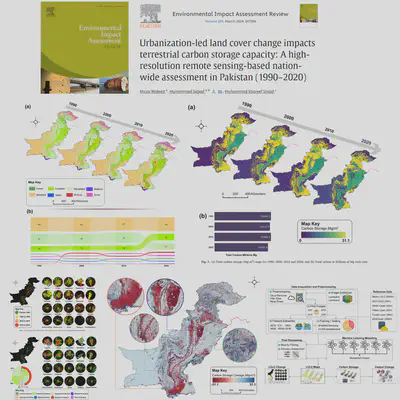
While carbon sequestration is significant to achieve the net zero and plays an important role in climate change mitigation, urbanization-led land use land cover (LULC) changes are causing significant impacts on the carbon stocks of terrestrial ecosystems. Despite rapid urbanization in Pakistan, previous studies focus solely on localized areas without documenting the influence of urbanization on carbon stock. Hence, insights regarding the carbon storage dynamics (CSD) in response to LULC changes become essential to drive informed decisions and policies. In this context, we leverage high-resolution (30 m) remote sensing data to evaluate and map the grid-level spatial-temporal interactions between urbanization and CSD at the national scale in Pakistan during 1990–2020. To do so, multi-sensor earth observation data are retrieved and processed using the Google Earth Engine and the Integrated Valuation of Ecosystem Services and Tradeoffs models. Our findings indicate that urban areas have expanded exponentially (an increase of ∼1040%), resulting in reduced carbon storage (a decrease of ∼ − 5%). Major cities (e.g., Karachi, Lahore, Faisalabad) showed less urban sprawl while emerging cities (e.g., Rawalpindi and Peshawar) demonstrated higher urban sprawl, primarily due to shifting patterns from rangeland (∼47%) and agriculture (∼35%) to built-up class. Though some afforestation projects have increased forest carbon stocks in the northern region, there is a large north-south spatial heterogeneity in carbon storage loss across Pakistan. The presented high-resolution mapping of CSD over the past three decades advances our understanding of where and how much urbanization has influenced carbon sequestration, nationally. Considering the results, this study emphasizes the need for policies and management approaches that support sustainable urbanization, which does not compromise carbon pools in the country.
Mirza Waleed
PhD Candidate | Google Developer Expert
Mirza Waleed | PhD Candidate | Google Developer Expert in Earth Engine