BAM: Self-Supervised Burn Area Mapping
BAM is a revolutionary, self-supervised machine learning framework designed for near-real-time mapping of wildfire burned areas globally. It bridges physics-based spectral analysis with data-driven ML refinement to eliminate reliance on manual training data, achieving robust 30-meter resolution mapping that resolves sub-pixel heterogeneity across diverse ecosystems and topographies.
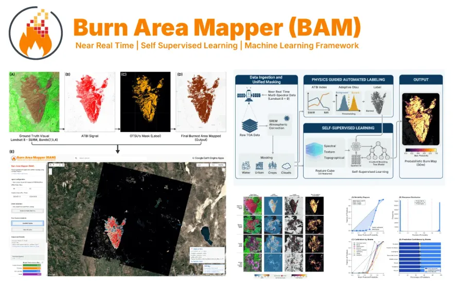
Objective. Accurate and rapid mapping of burned areas is critical for post-fire recovery, yet operational frameworks frequently struggle with atmospheric obstruction, sub-pixel heterogeneity, and a lack of reliable training data. BAM addresses these bottlenecks by introducing a globally transferable, zero-shot methodology.
Approach. Developed a hierarchical pipeline that bridges physics-based spectral analysis with data-driven machine learning. The novel self-supervised architecture generates physics-informed “weak labels” via an Automated Temporal Burn Index (ATBI) and adaptive Otsu thresholding—eliminating manual training data. It integrates Simplified Atmospheric Correction (SREM) and a multi-dimensional feature space to robustly suppress noise from shadows, clouds, and diverse vegetation.
Impact. Validated across 15 diverse global wildfire events, BAM achieved a highly stable mean F1-score of 0.994. Benchmarked against the industry-standard MODIS MCD64A1 product, the 30m Landsat-based framework demonstrated up to a 93% resolution gain in detecting fragmented burns. The framework is open-source and accessible via a Google Earth Engine web application and a Python API.
Related Projects
Interested in collaborating or have questions about this project?
Get in Touch