Flood Risk Analytics for Pakistan
High-resolution (30m) flood susceptibility mapping and population exposure analysis for Pakistan, integrating ensemble machine learning with geospatial big data to support national disaster risk reduction.
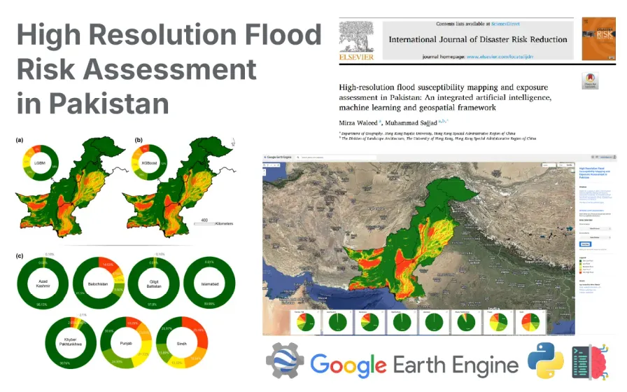
Objective. Pakistan is among the most flood-affected countries globally, yet lacks comprehensive, high-resolution susceptibility data to inform disaster risk reduction at the national scale.
Approach. Built an integrated geospatial framework combining ensemble machine learning models with Google Earth Engine to produce a 30-meter resolution flood susceptibility map for Pakistan. The analysis incorporated topographic, hydrological, and climatic conditioning factors alongside population and infrastructure exposure datasets.
Impact. Findings show that approximately 29% of Pakistan’s land area is classified as moderate-to-very-high flood susceptibility, exposing an estimated 95 million people — concentrated in Sindh and Punjab provinces. Published in the International Journal of Disaster Risk Reduction. The framework is designed to be scalable and transferable to other flood-prone regions.
Related Projects
Interested in collaborating or have questions about this project?
Get in Touch